Technical data of the Salacgriva port
Salacgriva port is located by the NE side of the Gulf of Riga by Salaca river mouth, 100 km from Riga and 13 km from the border of Latvia and Estonia. Its territory:
In Salacgriva: on land – 14.4 ha, in the sea – 28.6 ha
Access by motor road:
The closest road to Salacgriva port is VIA “Baltica” (distance from the port 300-400m)
Salacgriva port vessel channel navigation information:
Salacgriva port floating light “P”
|
Coordinates |
570 44.80’ N 240 17.78’ E |
|
Light characterization |
M0 (A)B. 10.2s |
|
Sector |
3600 |
|
Height above the average water level |
2 m |
|
Visibility |
3 nautical miles |
Port channel: length 3300 m (1.8 nm), width 70 m.
Port baseline: 2520 3 - 720.3
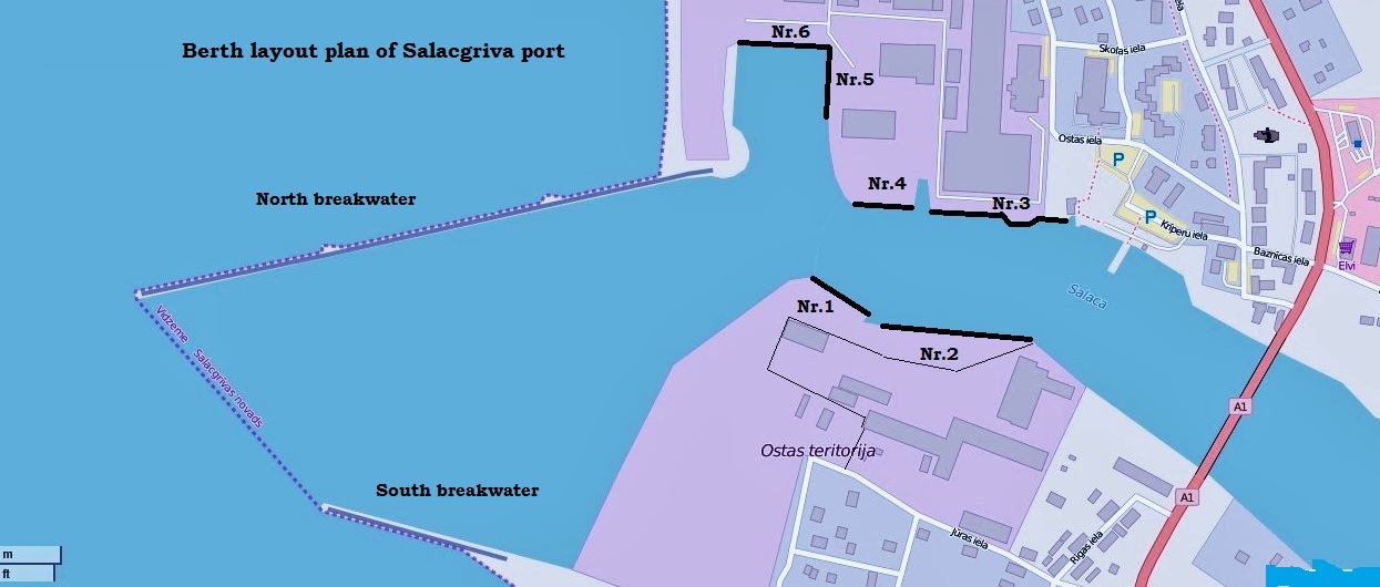
Berth layout plan of Salacgriva port:

|
Berth Nr. |
Length (m) |
Allowed draught (m) |
The owner, user of the berth |
|
1. |
80 |
5,6 |
Owner – Salacgriva Port Authority, rented by SIA "Salacgriva Nord terminal”, used for cargo handling. |
|
2. |
145 |
3,5 |
Owner – Salacgriva Port Authority. |
|
3. |
157 |
2,2 - 4,0 |
Owner – Stock Company “Brīvais Vilnis”, used by fishermen. |
|
4. |
70 |
5,6 |
Owner - SIA "Salacgriva Nord Terminal”, used for cargo handling. |
|
5. |
81 |
5,0 |
Owner - SIA "Salacgriva Nord Terminal”, used for storing cargo, vessel mooring without cargo operations. |
|
6. |
100 |
5,0 |
Owner - SIA "Salacgriva Nord Terminal”, used for storing cargo. |
 (+371) 64 071 111
 (+371) 64 071 111

 Ostas iela 6, Salacgrīva